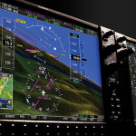
STARs are like a box of chocolates — you never know what you’ll get. Some arrival proedures are elegant and well-designed. Others? Not so much. Read more →


STARs are like a box of chocolates — you never know what you’ll get. Some arrival proedures are elegant and well-designed. Others? Not so much. Read more →

The techniques we use to teach instrument flying are sometimes panned as old, inefficient, or boring. I take exception with that viewpoint. Read more →

The FAA wants to double the amount of sim time which can be credited toward an instrument rating, but a negative comment on their proposal temporarily derailed the effort. So who’s right? Read more →
Simulating partial panel used to be so easy: slap a cover over one or two of the instruments and let the fun begin! In an era of integrated glass panel avionics, however, it’s not always so simple. Take the G1000 for example. The FAA doesn’t like us pulling circuit breakers, so they ask instructors and examiners to use a method that’s far less realistic. That might be better for the electronics… but what about the pilot? Read more →

The most common landing procedure used by IFR airplanes is the visual approach. It’s fast, efficient, and simple. So why did the crew of Asiana 214 have such a hard time with it on a good clear day? Because quality IFR flying starts with a solid VFR background — and VFR flying is something ab initio pilots see very little of. Read more →

Father may always know best, but air traffic controllers don’t. Yet 14 CFR 91.123 requires compliance with all ATC instructions. So when you’re asked to do something kooky, what do you do? Read more →
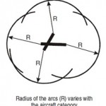
The FAA is adding new circling radii for some (but not all) approaches. Sounds good on paper, but I can foresee some unintended consequences that might not be too pleasant. Read more →
I’m often asked if an Instrument Proficiency Check can double as a flight review. Unfortunately, it can’t. Here’s why. Read more →

Visual Descent Points were designed to increase flight safety, but despite being “visual” when using them, there may be some nasty things out there that you can’t see. Read more →
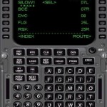
The FAA is introducing a new IFR instruction which will — in theory — make the system more efficient. But for it to work, pilots have to clearly understand the phraseology, meaning, and proper read-backs. Read more →