
Ahhh, fresh air and rain–manna from heaven!
It seems that Mother Nature has accomplished what 15,000 firefighters, dozens of aircraft, and millions of dollars could not. The fires are finally under control. It’s been two weeks of pure hell for many Southern Californians, not to mention something like a million acres of land and a couple thousand homes burned.
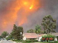
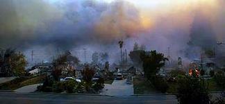
Disasters of this type always produce some powerful images. Here are a few I found particularly memorable:
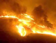
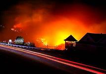
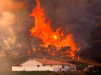
The damage is extensive, but it could have been much worse. I can only imagine the swath of destruction this inferno would’ve left in its wake had it reached into the San Fernando Valley.
The part of Orange County I live in was thankfully spared. Come to think of it, the whole county was nearly untouched by fire, though we did have quite a bit of fallout–ash, debris, and extremely poor air quality and visibility. The Santa Ana wind conditions carried all that stuff out toward the ocean, and that means it all had to pass through Orange County on its way out. Once the wind changed directions, the air cleared immediately even though the fires were still out of control.
The residual effects of this fire season are likely to remain with us for a long time. So much stuff was burned that it’s affected the most obscure areas of our lives. Let me give you one example. Have a look at this:
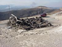
Any idea what this is?
It’s the Fillmore VOR (“FIM”), a heavily used radio navigation aid. Or should I say, it was the Fillmore VOR. It used to look like this.
Located northwest of the Los Angeles basin, FIM is the primary navaid for air traffic from northern California and the Pacific Northwest heading into southern California. It defines portions of two high-altitude jet airways and seven low-altitude Victor airways. The loss of this VOR affects nine departure procedures at six airports, 10 standard arrival routes (STARs) at six airports, and 30 approach procedures at eight airports. (Map)
The FAA says the area has good radar and radio coverage, so controllers are vectoring air traffic along the route to compensate for the loss of FIM. There are no GPS routes in existence or planned that could be used to replace Fillmore VOR, and because of terrain and coverage issues, no other existing VOR signals could be used to compensate.
Few people in the L.A. basin would know what Fillmore was or think much about it. But the ripple effect from FIM’s destruction will cause air traffic delays as far away as Seattle for months to come.
Technology has effectively made the world a much smaller place. So the “butterfly effect” from this fire is going to reach across the country, if not the globe, in ways most of us may not even be aware of.
Here’s hoping we don’t see anything like it again for a long, long time.
ron, i have really enjoyed reading your editorial about the fire. i didn’t know about the wide effect that the fillmore vor had on aviation and communications. you constantly amaze me with your knowledge and ability to put things into proper perspective. the pictures that you posted were the ones that showed the real devastation.
love, aunt betty
The photo of what the Fillmore VOR used to look like is of a Doppler VOR. We also have what is known as a conventional VOR and mountaintop VOR. Judging from the “after” photo, Fillmore looks to be a mountaintop, not a Doppler.
Charles, thanks for the info on those two types of VORs. In flight training we studied VOR theory, service volumes, etc. but during VFR, IFR, commercial, and other training I don’t think the difference between doppler and moutaintop was ever touched on.
The photo of what Fillmore used to look like is just a generic image I got off the web somewhere. I did notice that it looks different that Oceanside and other VOR stations I’ve been able to examine up close, but figured it was close enough to illustrate the dramatic effect the fires had on the national airspace system. 😉